


Precinct 4, Valley County, Montana
About
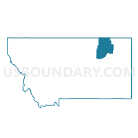
Outline

Summary
| Unique Area Identifier | 612331 |
| Name | Precinct 4 |
| County | Valley County |
| State | Montana |
| Area (square miles) | 647.19 |
| Land Area (square miles) | 647.03 |
| Water Area (square miles) | 0.16 |
| % of Land Area | 99.98 |
| % of Water Area | 0.02 |
| Latitude of the Internal Point | 48.28569940 |
| Longtitude of the Internal Point | -106.12826440 |
Maps


Graphs
Select a template below for downloading or customizing gragh for Precinct 4, Valley County, Montana


Neighbors
Neighoring Voting District (by Name) Neighboring Voting District on the Map
- Precinct 10, Valley County, MT
- Precinct 11, Valley County, MT
- Precinct 27, Roosevelt County, MT
- Precinct 28, Roosevelt County, MT
- Precinct 5, Valley County, MT
- Precinct 6, Valley County, MT
Top 10 Neighboring County Subdivision (by Population) Neighboring County Subdivision on the Map
- Fort Peck Reservation CCD, Roosevelt County, MT (8,847)
- Glasgow CCD, Valley County, MT (4,853)
- Fort Peck Reservation CCD, Valley County, MT (1,003)
- South Valley CCD, Valley County, MT (654)
Top 10 Neighboring Place (by Population) Neighboring Place on the Map
Top 10 Neighboring Elementary School District (by Population) Neighboring Elementary School District on the Map
- Wolf Point Elementary School District, MT (4,205)
- Frazer Elementary School District, MT (544)
- Lustre Elementary School District, MT (199)
Top 10 Neighboring Secondary School District (by Population) Neighboring Secondary School District on the Map
Top 10 Neighboring Unified School District (by Population) Neighboring Unified School District on the Map
Top 10 Neighboring State Legislative District Lower Chamber (by Population) Neighboring State Legislative District Lower Chamber on the Map
- State House District 31, MT (9,191)
- State House District 35, MT (8,987)
- State House District 36, MT (8,070)
Top 10 Neighboring State Legislative District Upper Chamber (by Population) Neighboring State Legislative District Upper Chamber on the Map
Top 10 Neighboring 111th Congressional District (by Population) Neighboring 111th Congressional District on the Map
Top 10 Neighboring Census Tract (by Population) Neighboring Census Tract on the Map
- Census Tract 9400.01, Roosevelt County, MT (4,549)
- Census Tract 9406, Valley County, MT (3,063)
- Census Tract 1001, Valley County, MT (1,513)